For all you bike riders and trail hikers out there, Google has just announced a plan to make your life easier. Now, when using their Map service, elevation profile data will also be included.
Bikers and hikers can now avoid steep hills (or go in search of them) with a new feature available on Google maps.
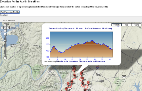
Rolling out on desktop versions first, Google is offering users a chance to map out elevation profile data when choosing a route to follow.
14 countries have been updated to include elevation profiles including; Austria, Australia, Belgium, Canada, Switzerland, Germany, Denmark, Finland, Great Britain, Netherlands, Norway, New Zealand, Sweden and the United States.
To view elevation data, users simply have to select the bike route feature when mapping a location. Then a representation of hills on the route selected will appear. Also included will be the total number of feet climbed along the route.
If all is successful, the new feature will be rolled out onto the mobile app later this year.
The announcement from Google Maps comes just weeks after the mobile app was revamped to include Uber data, improved business search and lane change information.
“Next time you’re caught up in a whirlwind of activity, make navigating your world a little easier,” Google Software Engineering Manager Jeffrey Hightower said in a blog post. “Take a moment to grab your phone, open up the Google Maps app, and find all you need to search, navigate and explore the world around you. Don’t worry—we’ve got you covered.”
You must be logged in to post a comment.